Meteorological support for Chinese expedition conducting survey at Mount Qomolangma
Source: China Meteorological News Press
Date: 2020/06/15
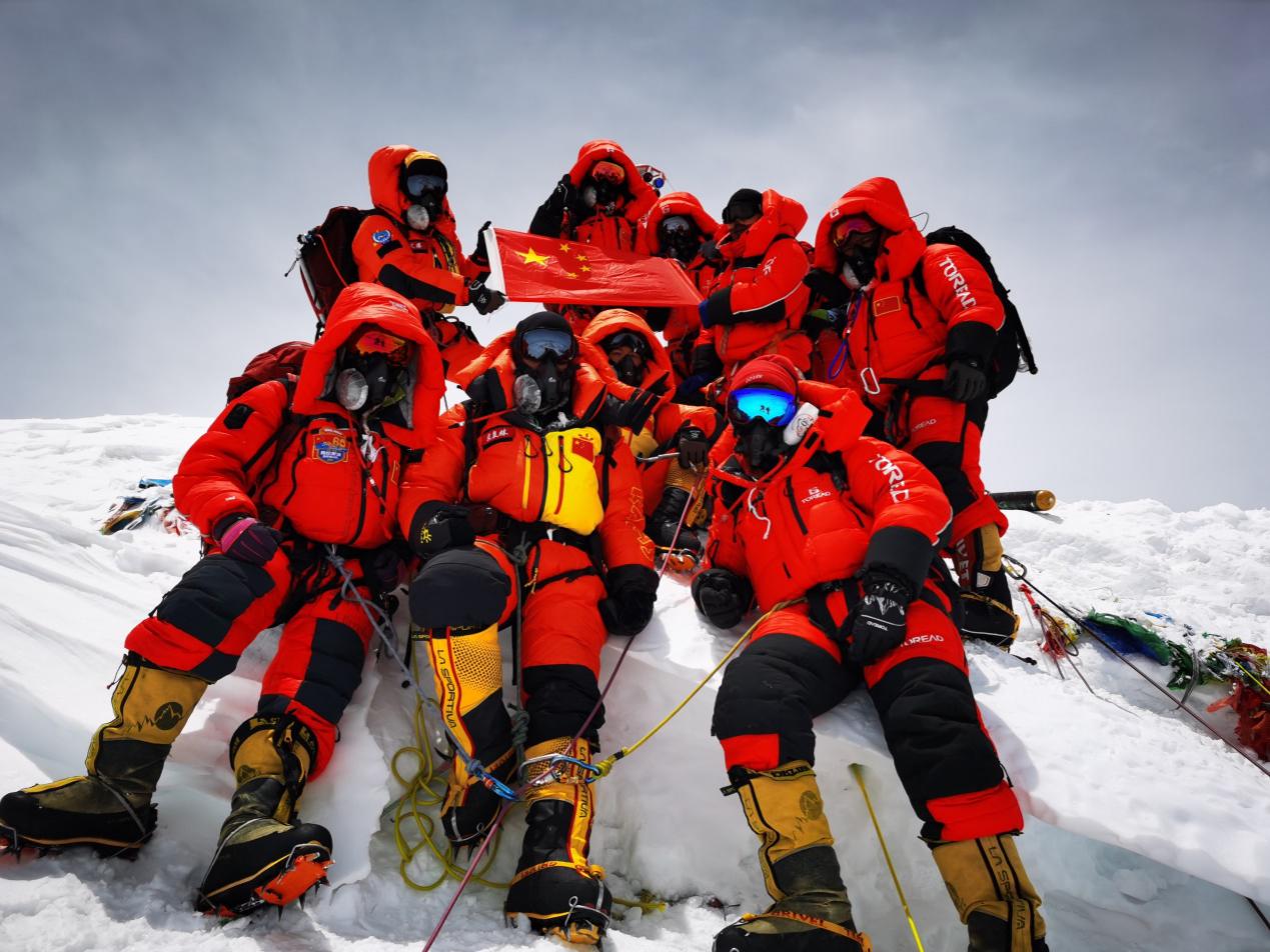
On the strength of the last “favorable weather condition”, 8 members of the Chinese survey team (hereafter referred to as the team) reached the summit of Mount Qomolangma on May 27, and remeasured the height of the world's highest peak.
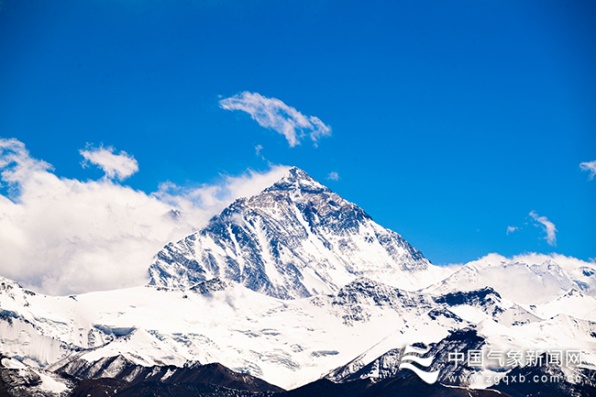
Mount Qomolangma Photoed by Fang Lequn At 11:00 a.m. on May 27, encouraging news came from the team. After human beings ascended to the summit of Mount Qomolangma from the North Slope for the first time 60 years ago, the Chinese national flag was waving at the peak of the world once again. After over 20 days, the team has traversed 6 camps, made third attempts to reach the peak, and surmounted the condition of the extreme low temperature, fierce wind, snowstorm under the super high altitude environment. This climb is not only a physical challenge but also human’s wisdom match against uncertain risks like weather.
On May 27, the team reached the peak of Mount Qomolangma Credits: Xinhua Mr. Wang Yongfeng, the chief leader of 2020 frontline headquarter of Mount Qomolangma measurement and climb marveled that meteorological support was the biggest support during the peak climb phase, and accurate prediction at 3-hour interval provided requisite for the success. 93 hours before reaching the peak, meteorological emergency vehicle entered the mountain camp. At 2:00 p.m. on May 23, the vehicle caught the attention, which signified that the assistance had arrived. The first two attempts of reaching the peak were affected by inclement weather conditions. Prior to the third attempt of the team, professional staff from Tibet Autonomous Region Meteorological Service (hereafter referred to as the Service) came and brought tremendous confidence to Wang Yongfeng and the entire team.
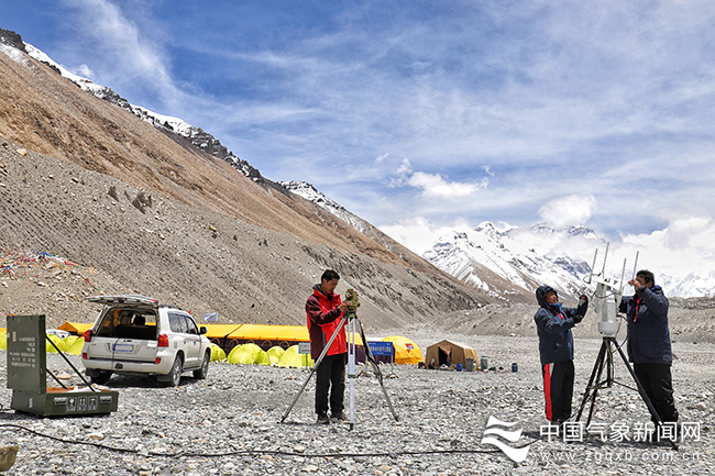
On May 10, members from meteorological detection support team sent out balloons in the mountain camp of Mount Qomolangma. Photoed by Fang Lequn On May 6, the team set off from the camp and planned to reach the peak on May 12. However, on the morning of May 9, the guide and the transportation team encountered snowy weather during climbing the ice cliff of the North Camp and were confronted with On May 21, the abrupt cyclonic storm AMPHAN brought snow to Mount Everest.The two chances of “favorable weather conditions” for reaching the peak were gone. Upon entering June, the monsoon will become more active. And the best season of climbing Mount Everest in the year will come to an end. Will it be a third chance? One urgent letter for help was sent to the Service. With the support of China Meteorological Administration (CMA), meteorological departments from Tibet formed the team overnight and dispatched meteorological emergency vehicle to the mountain camp.
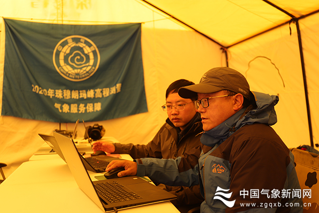
On May 10, members from meteorological detection support team carried out services drill in the camp Photoed by Fang Lequn On May 23, the first on-site meteorological consultation was held in the emergency response vehicle. The X wave band radar aboard the vehicle kept close tabs on the cloud system of the Mount Everest and rolled out the first meteorological forecast at 3-hour interval for mountain climb underpinned by National Meteorological Center (NMC) meteorological factors ensemble forecasting guidance products in Mount Everest region and Fengyun-4A meteorological satellite products. On May 24, the team set out for the peak once again. This time, they were more determined with the support of professional meteorological services. At 8:00 a.m. on May 25, 51 hours before reaching the peak, one upper-air detection data from Tingri county office was quite worrying. The wind speed reached 31m/s at the altitude of about 8000 meters in Mount Everest. This further exceeded the safety range of the mountain climb. When the wind speed is over 20 m/s, not a single team can “challenge” the Mount Everest in the fierce wind. Dai Huaguang, the chief forecaster from the Service right in the camp said that the Mount Everest region was characterized by high altitude, complex terrain, and volatile weather changes. And the wind, in particular, could often take on “hour-scale” changes within a day.
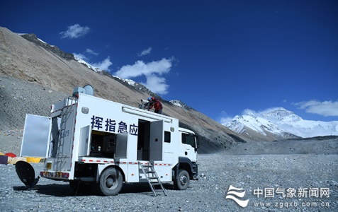
On May 23, the meteorological emergency vehicle entered the camp Photoed by Fang Lequn Mount Everest regions above the altitude of 5200 meters do not have natural conditions suitable for laying out meteorological monitoring stations. The meteorological detection service team situated in Tingri County to collect upper-air meteorological data at the altitude of 6000 meters, 7000 meters, 8000 meters, and 9000 meters, which become the most direct basis for on-site forecasting services. At 2:00 p.m. on May 25, Wang Yongfeng felt quite anxious and entered the tent of the meteorological forecasting service team. He said that the wind was quite fierce in the forefront and inquired about the condition right now. The team members traversed the gale gap with difficulty and marched to the camp at the altitude of 7790 meters. They had trouble setting up the tent for one hour amidst the gale and could only take shelter from the gale with stones in their arms. Keep it up or drop the mission? Everything depended on how the gale would evolve in future.
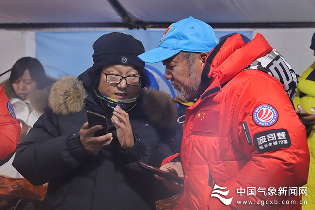
After entering the camp on May 23, the meteorological forecasting service team judged weather trend in the camp Photoed by Luo Sang Meteorological departments referred to guidance forecast from NMC, analyzed circulation trend during the intensive consultation, applied to increase the frequency of releasing the sounding balloon, provided data support with close and coordinated work. According to the judgement of the team, the wind intensity would dwindle at the night of May 26. This symbolized the gale will “make way for” the attempted climb before the dawn of May 27. The headquarter and the team decided to keep up the work. At 2:00 a.m. on May 27, 9 hours before reaching the peak, 8 members and the camera team set off for the peak. People in the headquarter tent of the camp held their breath and listened to the call at the ends of the walkie-talkie. The question about the weather at the altitude of 8300 meters was preying on the mind of Wang Yongfeng when the announcement of reaching the peak came. There was snowdrift and the wind was not very strong, was the response from the forefront. Luo Bujian, the chief forecaster from the Service sitting next to Wang Yongfeng breathed a sigh of relief.
At 7:00 a.m. on May 27, Luobu Jiancen briefed Wang Yongfeng the latest weather forecast. Photoed by Luo Sang Will snowdrift affect the climb to the peak or the descent? Just about half an hour ago, Luobu Jiancen informed the headquarter of the period of the snow abatement. Although the weather conditions were not ideal, the short term chance of “favorable weather condition” emerged. Under the sky of the Mount Everest, people were sleepless. The meteorological forecast at 3-hour interval was passed in the headquarter. And people were fully engaged each time the forefront sent back the information via the walkie-talkie. Finally, the climb to the peak took 3 hours more than the projected time span. Wang Yongfeng remarked that it could indicate how arduous the climb environment was. While announcing the success of the summit, the third white sounding balloon was released to the sky at the Tingri County Meteorological Office. For the meteorological service team members of upper-air sounding, the long-awaited "tense moment" had just begun. Afterwards, they needed to release the sounding balloon every two hours, providing meteorological reference for the results correction of the height measurement.
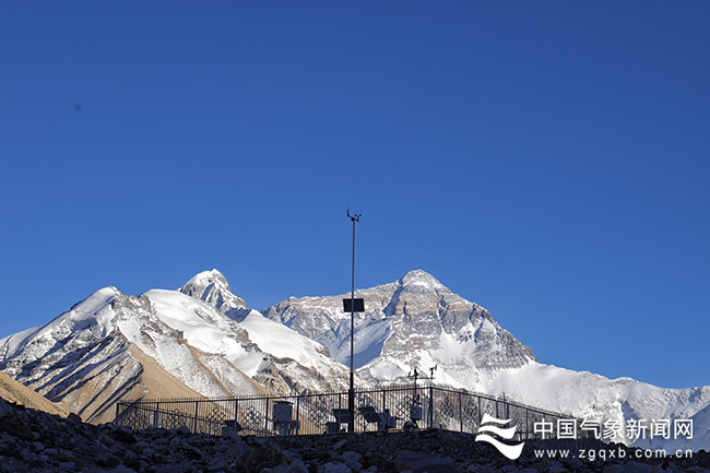
Automatic meteorological station at then altitude of 5200 meters in the camp Photoed by Luo Sang Providing refined services for major events of the Mount Qomolangma region is a kind of inheritance for the meteorological departments. On May 25, 1960, Chinese mountaineering team players Wang Fuzhou, Qu Yinhua and Kampot reached the summit from the north slope of Mount Qomolangma for the first time in Chinese history. Before the success summit was recorded in history, in 1958, the former Central Meteorological Administration sent a meteorological surveying team to arrive at the Everest area to collect data in advance and carried out relevant research on weather forecast for the Everest.
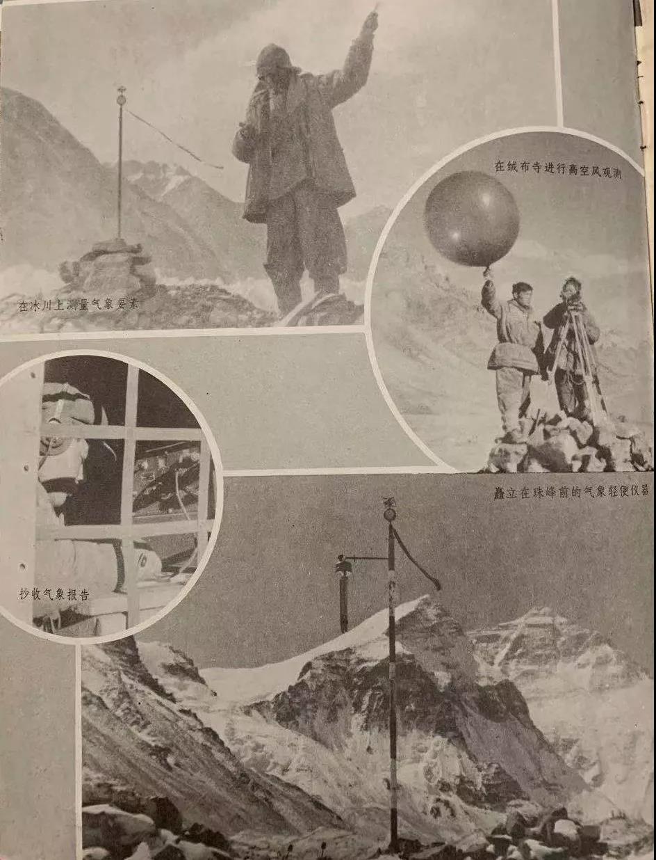
The forecaster provided service at Mount Everest In March 1960, the meteorological service team, who had been working here for two years, went up the mountain again with the mountaineering team. In mid-May, the meteorological service team issued a forecast showing that after May 19, there would be good weather for 4 to 5 days, which was suitable for climbing the main peak. In order to enhance the role of meteorological services, three meteorologists formed a mobile weather station and climbed to the 6400-meter frontline from the base camp. They used the walkie-talkie to communicate and provide on-site weather service for the summit.
Some meteorological service data of the Everest in 1960 At 4:25 on May 25, 1960, the Chinese reached the summit of Mount Everest for the first time. Since then, during every the summit of the Everest and scientific research projects, the famous summit in 1975 included, meteorologists were direct participants. They provided key forecast service, and served as unsung heroes at the base camp above 5000 meters. Every time is an exceptional experience. Badun, a 44-year-old weather forecaster, has been always rooted in Tingri County Meteorological Office, a weather observatory with first-category arduous conditions. This year’s meteorological service for the summit of Mount Everest has been the third In 2008, the Beijing Olympic Torch was successfully passed on the summit of Mount Everest. As the meteorological support staff at that time, Badun had stayed at the base camp for more than 30 days.
The meteorological services in 2008 Editor: Liu Shuqiao, Hao Jing Previous issues
|