Highlights of typhoon monitoring and prediction tools in China
Source: China Meteorological News Press
Date: 2020/07/15
Credits:National Satellite Meteorological Center “Sharp vision” of meteorological satellites Meteorological satellites can carry out intensive observation, provide high frequency and high quality observation data, and proceed with observation of the targeted area every 30 minutes. For instance, targeted at typhoon Lekima in 2019, Fengyun-4A satellite activated the model of intensive observation, followed satellite dynamic state closely, and provided high frequency and high quality observation data.
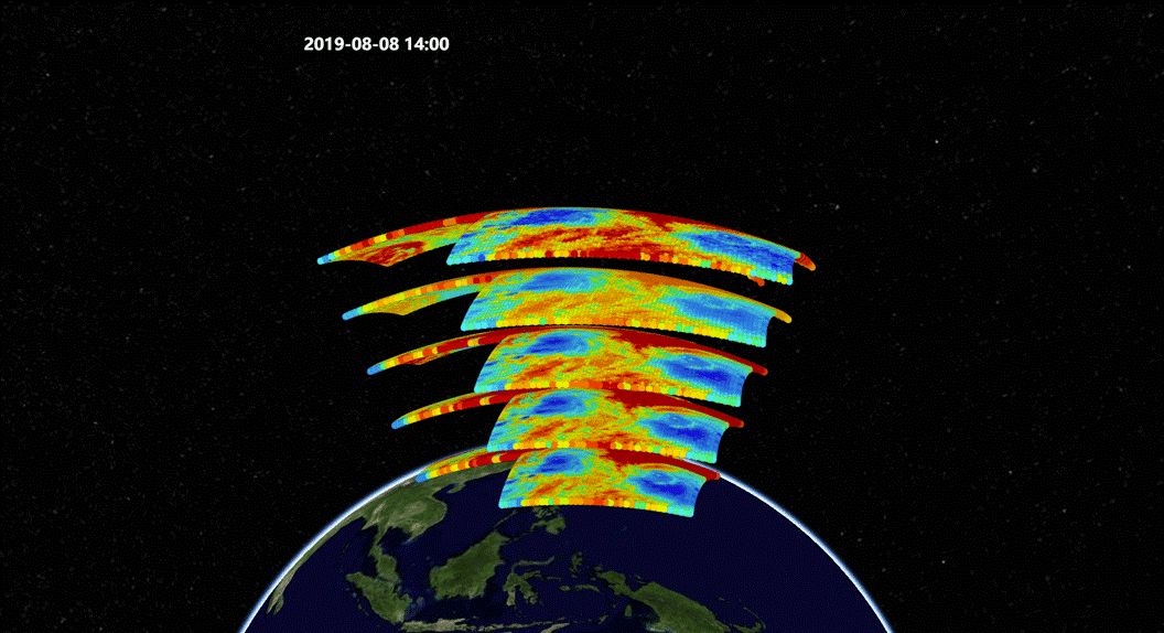
Typhoon Lekima in the “eye” of FY satellite in 2019 Geostationary Interferometric Infrared Sounder (GIIRS) of FY-4A satellite activated regional intensive observation. From 10:00 p.m. on August 8, 2019, it started to complete the observation of one targeted area every 30 minutes, and provided atmospheric temperature and humidity vertical profile data of areas susceptible to the typhoon.
GIIRS aboard FY-4A satellite carries out intensive observation of targeted area every 30 minutes FY-4A satellite interacted with numerical weather prediction (NWP)system of GRAPES,determined the areas sensitive to observation affecting prediction of eastern regions in the following 48 hours via the global tangent linear adjoint model, set the preliminary targeted area demonstration, made subtle adjustments combined with the features of FY satellites, and finalize the targeted observation area.
Typhoon Multi-channel synthetic animation during the intensive GIIRS observation of Lekima GRAPES global 4D-Var system assimilated and applied the intensive observation data, came up with better analysis field, improved NWP results, and provided reference for typhoon track prediction.
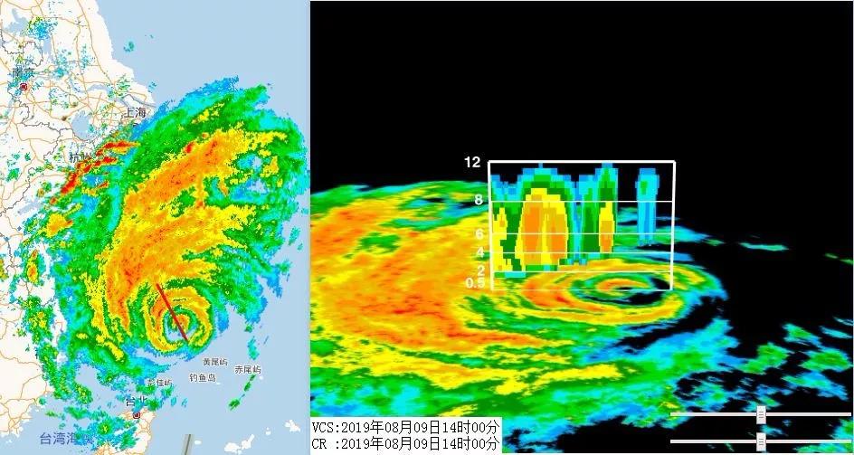
Monitoring master of radar It can assist the simultaneous comparison of myriad observation data, capture change features of intensity and structure during the landing process of the typhoon, and provide three-dimensional data. On the strength of the latest integrated meteorological observation product system of “Tianyan”, forecasters can visually conduct comparative analysis of myriad observation data from radars, ground automatic stations, island observatories, buoy stations in open seas, and carry out integrated judgement of the latest location and intensity information of the typhoon.
The monitoring images of the Tianyan system It can dynamically monitor convection development and evolution of diverse areas during the typhoon landing process, and provide change features of intensity and structure during this process for refined typhoon wind and rain prediction. 9日14时天气雷达回波及台风剖面图
Weather radar echo and typhoon profile map at 2:00 p.m. on August, 9, 2019
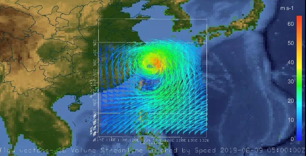
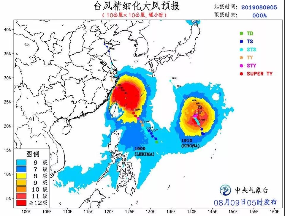
Real scene analytical field image from 8:00 to 13:00 on August 9, 2019 In Shandong, the provincial meteorological observatory has developed single elevation radar quality control algorithm, set up near real-time radar mosaic system, and shortened the time lapse of radar mosaic to one minute, which has effectively ramped up the real-timeliness and accuracy of typhoon and severe convective weather radar monitoring. Capturing the wind This technology can revise NWP products of tropical cyclone wind field, and assist forecasters in making more refined predictions. It adopts the tropical cyclone wind field dynamic interpretation technology to solve the problems that TC wind field NWP products lack effective and objective revision method
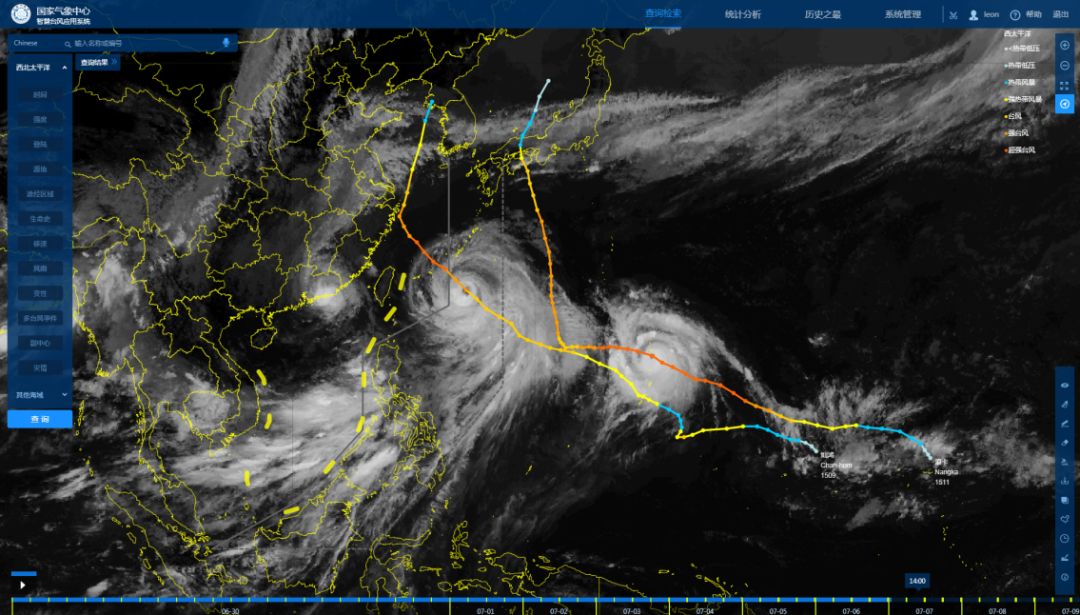
Refined gale prediction of typhoon This technology combines the subjective prediction about TC track and intensity made by forecasters with TC wind field prediction produced by NWP. It has harnessed subjective prediction information of track and intensity to conduct dynamic correction of TC wind field prediction by NWP, come up with the corrected TC near ground wind field distribution, and assist forecasters to make more refined predictions. Platform of intelligent retrieval It can elevate the automatic and intelligent level of typhoon operation, and helps improve prediction perspective, as well as enhancing the work efficiency of forecasters. In 2019, the intelligent typhoon retrieval platform was developed by adopting advanced technologies like information-based technology, big data, cloud computing, and artificial intelligence. This system focuses on the demands of tackling intricate typhoon prediction and services, and elevates the automatic and intelligent level of typhoon operation.
The intelligent typhoon retrieval platform In typhoon prediction and services, retrieving similar typhoons in history can serve as crucial prediction reference. This system has not only provided the retrieval of similar tracks, but also showcased corresponding circulation situation and satellite cloud images, which can help improve the typhoon prediction perspective. Besides, harnessing the statistical and analytical functions of the system can partially replace intricate manual work in service material production, which can enhance the efficiency of the forecasters. Tool of Ozone detection Ozone within the scale 7 circulation of the typhoon has been successfully detected for the first time. Near ground atmospheric laser radar has been laid out. Shanghai Institute of Typhoon (SIT) of China Meteorological Administration (CMA) has laid out the radars in Zhoushan, Taizhou, and Wenzhou, to detect high spatial and temporal resolution features of atmospheric turbulence within the height of 300 meters. The new scientific product of Meteorological Observation Center of CMA (MOC) was subjected to real scene testing during typhoon Nuri, 2020. The typhoon center locating algorithm based on real scene grid point data can automatically identify the center of each layer of the typhoon and put on visible demonstration. According to Guo Jianxia, the researcher from the center, seen from the typhoon center movement image on June 13, the distribution of lower and medium layers of the typhoon were relatively vertical. The features of the high layer were not noticeable and the development intensity was rather weak from the vertical direction. Then the features of typhoon Nuri, like asymmetry and rather weak intensity were swiftly discerned. National Satellite Meteorological Center (NSMC) has given play to the scientific advantages of FY meteorological satellites in capturing the nascent typhoon on the sea. It has harnessed the microwave observation technology of FY-3 satellites to capture the image of the asymmetrical cloud system and accurately identify its three-dimensional temperature and humidity structure, and heavy precipitation cloud system, which has played a key assistance role in grasping typhoon structure and determining precipitation area.(July.15) Editor: Liu Shuqiao Previous issues
|