SaturdayMay 172025

At 3:22 a.m. on November 22, 2016, the Long March-2D rocket carrying carbon dioxide monitoring satellite blasts off from the launch pad at the Jiuquan Satellite Launch Center Source: Xinhuanet
At 3:22 a.m. on November 22, 2016(BJT),the Long March-2D rocket carring China's first global carbon dioxide monitoring satellite (hereafter referred to TanSat) blasts off from the launching pad at the Jiuquan Satellite Launch Center. China is the third country after Japan and the United States to monitor greenhouse gases through its own satellite. The successful launch and stable follow-up in-orbit operation will enable China to monitor global carbon dioxide level, and promote the comprehensive understanding of global carbon cycle’s effects on climate change.
The fourth IPCC Assessment Report has demonstrated that major global greenhouse gas and methane concentrations have reached the peak since 25 million years and are poised to further increase. At the global scale, successive monitoring and analysis capabilities of carbon dioxide, one of the key factors influencing climate change, are still weak. The accurate monitoring of global carbon dioxide emissions has become the emerging demand of effectively launching climate change studies.
With instruments onboard such as hyper spectral and high resolution carbon dioxide detector and the aerosol detector, the satellite can access global carbon dioxide distribution map through the ground-based data reception, processment and verification system on a regular basis. On the strength of these instruments and capabilities, China has made its way into the global frontier in monitoring carbon dioxide. In the meanwhile, TanSat will effectively enhance understanding of the global carbon cycle, improve the reliability and stability of climate change prediction results, and provide evidence for actively responding to climate change.
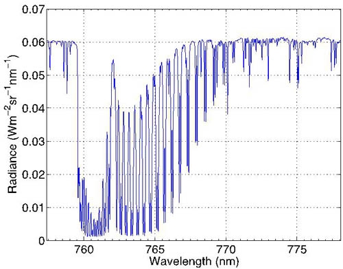
Observation spectrum by main plane tracking model from the oxygen absorption band
As the main user of TanSat, CMA attaches vital importance to the launching of TanSat. It is the concerted effort made by Chinese Academy of Sciences (CAS), CMA, and China Aerospace Science and Technology Corporation. TanSat is a major mission of the Ministry of Science and Technology in halting climate change and enhancing the capability of monitoring global carbon dioxide. CMA National Satellite Meteorological Center (NSMC) takes responsibility for the research, construction and operation of ground-based data reception and processment as well as carbon dioxide inversion and verification system.
On January 12, 2017, the payload carried from TanSat for the scientific experiment which was lifted off on December 22, 2017, got to work. The first batch of observing data has been obtained from TanSat including the first group of oxygen and carbon dioxide absorption spectrogram generated through hyperspectral carbon dioxide monitor and then the ground system. It is China’s first high resolution oxygen and carbon dioxide absorption spectrogram that is obtained from the space.
The satellite runs on sun-synchronous orbit, 700-kilometre above the earth. The scientific objective of this satellite is to acquire global and regional carbon dioxide distribution map with accuracy higher than 4 ppm (part per million), so that China is able to monitor carbon dioxide in the global atmosphere.
TanSat is equipped with the Atmospheric Carbon-dioxide Grating Spectrometer (ACGS),the multiple-band Cloud and Aerosol Polarization Imager (CAPI). It is worth noting that the ACGS represents a pioneer in hyperspectral monitoring of the greenhouse gases from space for China. With these sophisticated instruments onboard the satellite can access global carbon dioxide distribution map through the ground-based data reception, treatment and verification system on a regular basis. Furthermore, TanSat observes carbon dioxide at an accuracy level better than 4 ppm.

Observation spectrum by the main plane tracking model from the weak carbon dioxide absorption band
The first batch of observing data shows the sound operation of both the satellite and the ground system. Moreover, the satellite platform has realized various complicated pointing models based on the instruction with the stable operation, sound function as well as sound payload condition. Ground application system functions smoothly in terms of satellite-ground communication, as the data reception and remote data synchronous transmission system of three ground stations in domestic Kiamusze and Urumqi as well as Kiruna of Sweden operate steadily. The satellite promptly receives total observation data and synchronously transmits them to the NSMC. Meanwhile, the ground application system works properly in terms of operational control, computer and networking, data archiving and service, and data pre-processing. As a consequence, the ground application system can accomplish data pre-processing and generate primary data products in accordance with the task requirement.

Observation spectrum by main plane tracking model from the strong carbon dioxide absorption band
It is reported that by data inversion of TanSat, CMA has successfully obtained the first global chlorophyll product. This feat signifies that China can measure stored carbon in vegetation via global fluorescence image, which facilitates accurate mastery of vegetation growth, global carbon sink distribution, and the response of land surface vegetation to climate change.

Observation spectrum by main plane tracking model from international peers’ oxygen and carbon dioxide absorption bands
Chlorophyll fluorescence can timely capture the real operation of plant photosynthesis, and diagnose the health condition of plants. However, affected by myriad impacts, accurate collection of chlorophyll fluorescence from satellite is confronted with colossal challenges. Firstly, induced by sun light, the number of fluorescence emitted by vegetation chlorophyll is minimal. Besides, chlorophyll fluorescence is superimposed on dominant vegetation reflection energy. Chlorophyll fluorescence is the first seminal application of TanSat, which leverages super-spectral resolution data, enabling dynamic observation of global atmospheric concentration and accurate reversion of vegetation chlorophyll fluorescence. This will pronouncedly elevate global carbon source observing capability.
Relevant studies have been carried out and the results have demonstrated that this product can explicitly showcase robust productivities in areas such as North America Corn Belt, European Plateau, East Asian plantation area, and Southeast Asia. Actually, China’s TanSat has boasted a global cutting-edge level, which can find its application in monitoring global vegetation growth condition and productivity.

Counterparts from the United States, Euoropean Union and South Africa and Mr. Huangwei launched the earth model embodying satellite data sharing Photoed by Zhang Xingying
From October 23 to October 27, 2017, the 14th plenary session of GEO and related activities kicked off in Washington, the United States. Mr. Huang Wei, joint president of Group on Earth Observations (GEO) and deputy minister of Ministry of Science and Technology led the Chinese delegation and showcased cutting-edge achievements in earth observation such as TanSat and FY-4A projects to the entire world.
From October 24,2017, China's first global carbon dioxide monitoring satellite data is open to the public, which means that China is capable of providing carbon dioxide measurements in the wake of the United States and Japan. Users can have access to the dataset.

From this image, we can see that the carbon dioxide concentration in northern hemisphere was higher than that in the southern hemisphere in spring (April) of 2017, due to the anthropogenic emissions. 
During April and July of 2017, the concentration took on a diminishing trend. By comparison, we can see the “fixed carbon” effect of ecosystems was changing along with the seasons.
Recently, first global carbon dioxide map produced by the first TanSat in China has been released to the public. The availability of this map is conducive to accurately monitor the temporal and spatial variation of carbon dioxide, emissions and absorption, and the correlation between in-depth research and global warming, and then perform accurate prediction of climate change in the future, and help countries across the globe to plan out reasonable emissions reduction scheme.
Judged from this map, due to human emissions, northern hemisphere has witnessed high carbon dioxide concentration and the southern hemisphere has witnessed low concentration in April, 2017. From April, 2017, to July, 2017, carbon dioxide concentration is on the downward trend in northern hemisphere. By virtue of comparison, the role of ecosystem in carbon sequestration crops up with the elapse of seasonal change. Furthermore, carbon dioxide concentration over North America, Europe, East Asia, and Southern Asia exceeds that in other regions, which is incurred by frequent local human activities. Mr. Yang Dongxu, deputy researcher from TanSat application team, the Institute of Atmospheric Physics, Chinese Academy of Sciences, introduced that these maps could help people quantify and analyze carbon dioxide distribution, put observation data into assimilation model, realize quantifiable carbon sink source computing, and track human carbon emissions.
Its scientific objective revolves around acquiring global carbon dioxide concentration information, with a bid to accurately manifest how human activities and natural system This map is based on the whole monthly results of observation inversion data when TanSat traverses. In the recent Advances in Atmospheric Sciences, the team has introduced this results and the inversion computing method of TanSat.
In the next phase, scientists plan to perform comparative verification between TanSat data and ground carbon dioxide observation stations data. Currently, carbon dioxide spectrum data (primary level data) has been shared across the globe. In the future, TanSat will release secondary data on a regular basis.(Apri. 24)
Reporter: Lu Jian, Niu Yanyuan
Editor: Liu Shuqiao


Copyright© 2011 China Meteorological Administration All Rights Reserved