At 2:35 BJT on November 15, 2017,A Long March-4C rocket carrying FY-3D meteorological satellite was successfully launched at Taiyuan Satellite Launch Center in Shanxi province. As the fourth member of second-generation polar-orbiting meteorological satellites, FY-3D will inform people of future weather conditions earlier, mitigate natural disasters’impacts on economy and society, and lift people’s livelihood. Furthermore, equipped with greenhouse gases probing capacity, FY-3D can play a proactive role in tackling climate change, and serve ecological civilization construction and “Belt and Road” Initiative.
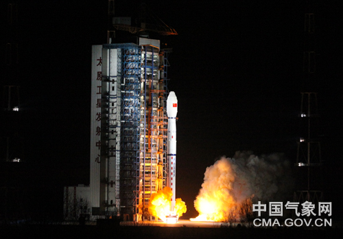
FY-3D satellite was launched at Taiyuan Satellite Launch Center Photoed by Zhang Hongwei
From the view of consistency of meteorological satellite sequence, FY-3D satellite will replace FY-3B which has been operated for 8 years in space, launch network observation with FY-3C, and stand on duty with FY-4A at 800 kilometers and 36 thousand kilometers respectively in space, constituting the new-generation high-low orbit meteorological satellite constellation.
10 state-of-the-art instruments are onboard FY-3D satellite. Among them, 5 instruments including Microwave Temperature Sounder (MWTS), Microwave Humidity Sounder (MHTS), Microwave Radiation Imager (MWRI), Space Environment Monitor (SEM), and Global Navigation Satellite System Occultation Sounder (GNOS) are instruments which have been onboard previous polar-orbiting satellites. Hyperspectral Infrared Atmospheric Sounder (HIRAS), Hyperspectral Near-infrared Greenhouse gases Absorption Spectrometer (GAS), Wide Angle Aurora Imager (WAI), and Ionospheric Photometer (IPM) are newly developed and are for the first time onboard the satellite. Medium Resolution Spectrum Imager (MERSI), as the core instrument, has been markedly upgraded and enjoyed a higher level of performance.
Enhancing the accuracy and timeliness of weather forecast has remained the priority tasks of meteorological satellites. Mr. Han Wei, researcher from China Meteorological Administration (CMA) Numerical Prediction Center, introduced that HIRAS adopted the most sophisticated probing technology in the world. The spectrum has covered 1370 channels, up by 70 times compared with the number of previous instrument channels, which provides a more robust support for medium-and-long range numerical weather prediction (NWP) and enables high-impact weather forecast 5-7 days in advance.
MERSI is one of the core instruments onboard FY-3 series satellites. Upon improvement, it can rival the imager instrument onboard American JPSS-1 meteorological satellite. MERSI has integrated the functions of prior two imagers of FY-3 satellites and can obtain 250-meter resolution true color image on a daily basis. This instrument is categorized as the most advanced of this kind on the global arena. Mr. Zhang Peng, Commander-in-Chief of FY-3 satellite ground application system and Deputy Director of National Satellite Meteorological Center (NSMC), introduced that this instrument could conduct a highly accurate measurement of inversing clouds, aerosols, and ocean colors, providing scientific underpinning for ecological management at home and abroad, and disaster monitoring.
Besides, WAI and IPM onboard FY-3D satellite can play a key role in safeguarding China’s space infrastructure security and the smooth operation of national strategy of strengthening marine power.
It is worth noting that FY-3D is China’s first earth remote sensing satellite utilizing data from Antarctica satellite data reception station. 90% global observation data can be transmitted to China as of 80 minutes upon observation. Satellite-earth data transmission rate is up by 30%; computing capacity increases by about 20 times; data storage capacity is augmented by about 10 times.
So far, China has successfully launched 16 meteorological satellites, 9 of which are in on-orbit operation, which have provided a raft of global and regional earth observation information and data ranging from meteorology, ocean, forestry, agriculture, to civil aviation and made an essential contribution to national economy, and disaster prevention and reduction. Fengyun meteorological satellites input-output benefit ratio has surpassed 1:40. They have become the most applied satellites with the most fruitful benefits among China’s civilian remote sensing satellites.
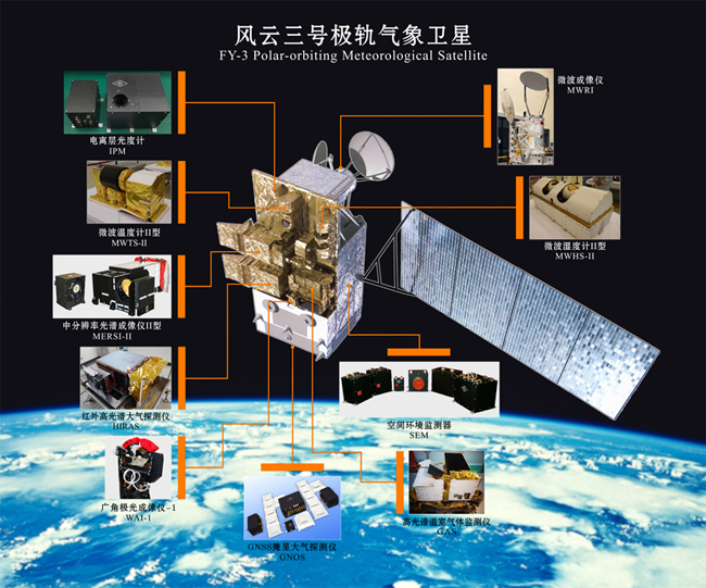
Instruments onboard FY-3D polar-orbiting satellite Photo from: NSMC
Fengyun meteorological satellites, as earth observation satellites with wide-ranging global reputation, have become the mouthpiece for Chinese strength. They have been incorporated into the global earth observation operational satellite sequence by World Meteorological Organization (WMO), and undertaken on-duty satellite mission for CHARTER mechanism, which have assumed an increasingly significant role. According to statistics, right now 77 countries and regions have access to or apply data provided by Fengyun meteorological satellites.(Nov.15)
Reporter: Lu Jian
Editor: Liu Shuqiao


Copyright© 2011 China Meteorological Administration All Rights Reserved