Top 10 weather and climate events in 2022 unveiled
Source: China Meteorological News Press
Date: 2023/01/19
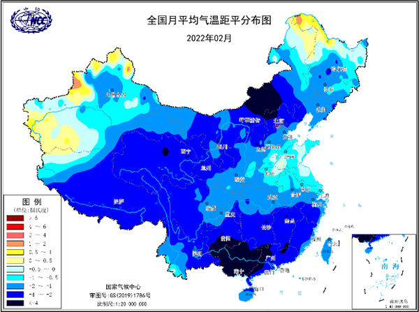
Recently, the result of the top 10 domestic and global weather and climate events in 2022 has been unveiled, a fresh call for effective adapting actions to climate change. The selection is held by Beijing Climate Centre. The selection results of the top 10 weather and climate events in China have reflected the major features of weather and climate conditions in 2022 in China. Let's have a look. 1. Low temperature, rain and snow process emerged during Beijing 2022 Winter Olympic and Paralympic Games, and meteorological departments provided elaborate services. In February 2022, the average temperature of China was 2.0℃ lower than that in the same period of normal years, and the precipitation was 56% higher, with features of cold and humidity. From November 11 to 14, 2022, Beijing, Tianjin, Hebei, Shanxi and Inner Mongolia witnessed snowfall, with the snow depth of 10 to 16 cm in northern and eastern Beijing, Datong and Xinzhou in Shanxi, Baoding, Langfang and Cangzhou in Hebei. Meteorological departments made an all-out endeavor to carry out precise monitoring, accurate forecasting and refined services to ensure the smooth host of Beijing 2022.
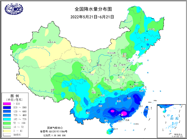
National average temperature anomaly distribution map in February 2022 2. The second strongest dragon-boat rainfall since 1961in history affected the Pearl River Basin. From May 21 to June 21, 2022, there were six heavy rainfall processes in the Pearl River Basin, with the accumulative precipitation exceeding 400 mm in most areas. Central-northern Guangxi, central-northern Guangdong, southern Hunan, and southern Jiangxi were subjected to 600 to 900 mm accumulative rainfall. Precipitation in most of the above areas was more than 50% higher than that in the same period of normal years. The average precipitation in the Pearl River Basin registered 440mm, 53% more than that in the same period of normal years, ranking the second highest in the same period since 1961.
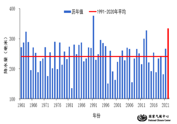
National precipitation distribution map from May 21 to June 21, 2022 3. The Songliao Basin suffered extreme rainfall, and the Panjin section around the Raoyang River breached. From June to July, 2022, the average precipitation in three provinces in Northeast China (334.9 mm, 39% more than that in the same period of normal years) ranked the second highest since 1961. The precipitation of Jilin (414.2 mm, 65% more) and the number of rainfall days (37.8 days) topped the charts in the history of the same period. The average precipitation of Liaoning recorded 420.6 mm, 70% more than that of the same period of normal years, and exceeded the total annual summer rainfall, which was the highest in the history of the same period in nearly 3 decades. Some road infrastructures were damaged or disrupted and agricultural products were also adversely affected.
Annual variation of precipitation in three provinces in Northeast China from June to July (1961-2022) 4. Heavy casualties were caused by short-term heavy rainfall in midsummer. From July 15 to 16, 2022, heavy rainfall occurred in central and northern parts of Sichuan. In Beichuan County, rainfall in 12 hours exceeded 50 mm in 21 meteorological stations, and in 8 meteorological stations the precipitation exceeded 100 mm. In Qingpian Township, Beichuan County, accumulative rainfall reached 102.5 mm in 6 hours on July 16, 2022. The heavy rain triggered flash floods that swept away some houses and disrupted transportation, power and communication. More than 20,000 people were affected.
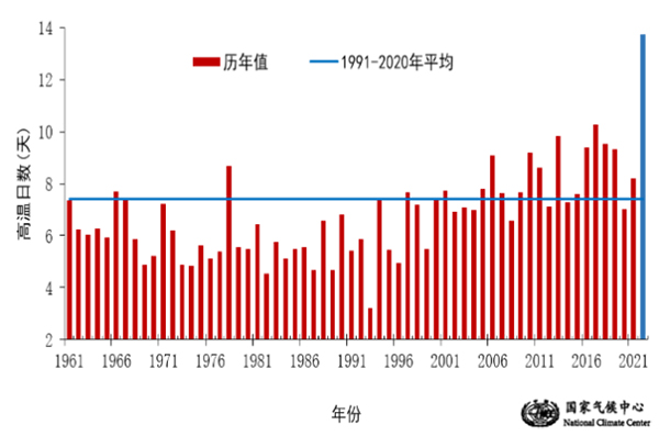
Heavy rainfall caused flash floods in Beichuan, Sichuan 5.The National Meteorological Centre (NMC) issued its first red warning of heat wave since 1961 as the strongest heat wave raged across China. From June 13 to August 30, 2022, large scale continuous heat wave process occurred in eastern parts of China, which lasted for 79 days in total, becoming the longest regional high temperature process since 1961. On August 13, 2022, NMC issued its first red warning of heat wave since 1961 when the meteorological warning system established in China. In this heat wave process, 1,692 meteorological stations witnessed high temperature of 35℃ or above (accounting for 70% of the total number of meteorological stations in China), which was the second most in history since 1961. The results showed that the overall intensity of this event was the strongest since the complete meteorological observation began in 1961. The continued high temperature has adversely affected human health, agricultural production and power supply.
Historical yearly variation of the national average number of high temperature days from June 13 to August 30 (1961-2022) 6. Drought condition continued in the flood season in the Yangtze River Basin and rain enhancement operation helped those affected areas. From July to the first half of November, 2022, the middle and lower reaches of the Yangtze River as well as Sichuan and Chongqing areas continued to experience heat wave and low rainfall, and were exposed to summer drought and autumn drought. The number of drought days in the Yangtze River Basin was 77, 54 days more than the same period of normal years, which was the most since 1961. On August 18, 2022, NMC and the National Climate Centre (NCC) jointly issued warning of drought for the first time since 2013.On August 27, 2022, China Meteorological Administration (CMA) dispatched several aircraft to conduct a large-scale air-ground joint rain enhancement operation in the catchment basin of Danjiangkou Reservoir for the first time to ensure water supply and electricity for the middle route of the South-to-North Water Diversion Project. The continuous high temperature and drought had a tremendous impact on agricultural production, water resources supply, energy supply and human health in the Yangtze River Basin, and also exerted a certain adverse impact on the local ecosystem.
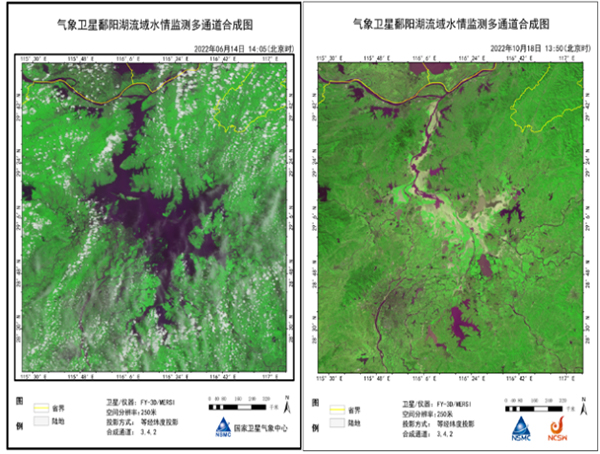
Satellite monitoring images of Poyang Lake on June 14 (L) and October 18 (R), 2022 7. Rare autumn typhoon Muifa made 4 landfalls and set the record of the northernmost typhoons making landfall since 1949. Typhoon Muifa, the 12th typhoon of 2022, made landfall in Zhejiang, Shanghai, Shandong and Liaoning four times between September 14 and 16, 2022, shattering the record for the northernmost landfall of a typhoon since 1949. Under the combined influence of Muifa and cold air, winds of scale 12 to 15 appeared in the coastal areas of Shanghai, Zhejiang and some islands and reefs, with the highest gust appearing in Xugong Island of Zhoushan, Zhejiang (scale 16, 53.6 m/s), and the cumulative gale of scale 12 or above in the sea surface of northeastern Zhejiang lasted for 12 hours. The cumulative rainfall in Shaoxing, Ningbo and Zhoushan of Zhejiang and Qingdao and Yantai of Shandong reached 250 to 500 mm, and 600 to 707 mm in Shaoxing Shangyu, Shengzhou and Yuyao, Ningbo. On the other hand, the rain brought by the typhoon also alleviated the drought condition in southern Jiangsu, Shanghai, northern Zhejiang and southern Anhui.
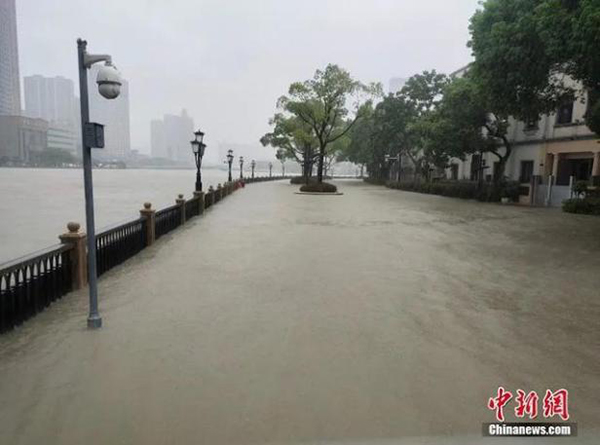
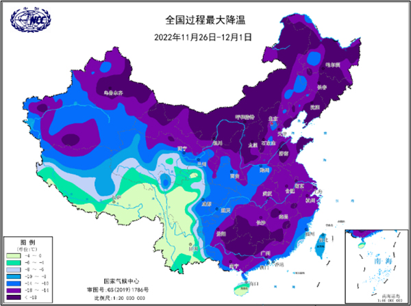
After typhoon Muifa came along, the pedestrian sidewalk in Ningbo, Zhejiang was submerged. 8. Frequent cold waves in autumn and precipitous temperature drop adversely affected public travel, farming and animal husbandry production. From October 2 to 6, 2022, a large-scale cold wave occurred in the central and eastern parts of China. The temperature drop in southeastern Henan, Anhui, Hubei and northeastern Hunan registered more than 20℃, and the temperature drop in Xinye and Qinyang of Henan exceeded 25℃. The cold wave put an end to Indian summer weather in southern China.From November 30 to December 1, 2022, most parts of China were hit by cold wave again, with precipitous temperature drop accompanied by rain, snow and strong winds in many areas. The temperature drop range above 14℃ has covered more than half of the country's total area (55%), and the temperature drop exceeded 18℃ in some areas.
The maximum cooling scale distribution map from November 26 to December 1, 2022 9. Twister weather was sporadic and frequent, and meteorological departments released forecasting and early warning for the first time. In 2022, a total of 25 twisters were recorded, including 11 of moderate or above intensity and six of strong intensity, the same as the average of the previous three years. On May 14, 2022, Wuchang in Heilongjiang was battered by a short wind, which was estimated to be a weak to moderate strength tornado. On July 20 and 22, 2022, two large scale strong convection processes occurred in Huanghuai River and Huaihe River. Meteorological departments, based on the latest monitoring and diagnosis technology, successfully issued a tornado forecast and early warning for the first time, to remind the public of bracing for potential disasters.
National twister distribution map in 2022 10. The Global Space Weather Center responded in time to ensure safety as the number of medium and above scale solar flares events surpassed the total number of those in the past three years. Solar activity has become increasingly active since December 2019, when the sun entered its 25th cycle. In April 2022, there were 28 moderate flares and 5 major flares, more than the total of those with moderate or above intensity in the previous three years. Solar flares can cause drastic changes in the ionosphere for a short time, leading to the interruption of short-wave communication between the ground and the upper air, and the low accuracy of navigation, thus adversely affecting the safety of aviation flight.
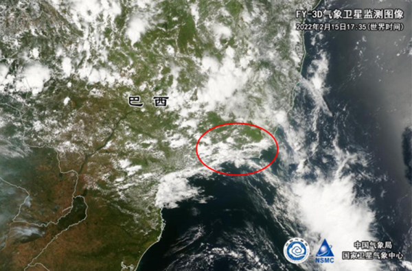
Image of the sun observed by FY-3E Here are the highlights of top ten weather and climate events across the globe. 1. Frequent severe rainstorm and flooding slammed Brazil and resulted in grave disasters and losses. From February 11 to 16, 2022, extreme precipitation occurred in many places in Rio de Janeiro State, Brazil. The average precipitation of the whole state registered about 67 mm, which was 1 to 2 times more than that in the same period of normal years. Petropolis was subjected to rainfall of 210 mm in three hours on February 15, exceeding the usual rainfall in February. It was the largest daily rainfall since 1932. From late May to early June, 2022, northeastern parts of Brazil were slammed by continuous heavy rainfall, with accumulated precipitation of more than 50 mm in most areas. Among them, western Roraima State and northeastern Ceara State experienced rainfall of 100 to 300 mm, with some areas exposed to more than 300 mm rainfall. Heavy rainfall has caused severe flooding and landslides in many parts of Brazil.
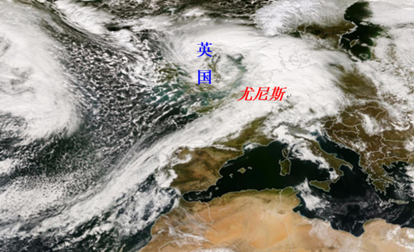
The cloud cluster affected Petropolis, Brazil captured by FY-3D 2. Severe storm “Eunice” enveloped West Europe and gust broke record in England. On February 18, 2022, the Atlantic storm "Eunice" battered a few countries in Western Europe. Gale with force of 8 and higher occurred in southern United Kingdom, English Channel, southern North Sea, Western Europe and northern coastal regions of Central Europe. The gust in southern United Kingdom and English Channel reached scale 10 to 12. A maximum gust of about 196 km/h (54.4 m/s) was observed at the Needles, on the Isle of Wight, UK, setting a record for the highest gust ever recorded in England. More than 400 flights were cancelled and a large number of trains stopped running. Power facilities were damaged in many places and more than 1.3 million households lost power.
The image of Storm Uunice captured by FY-3D 3. Typhoon Megi and Nalgae walloped the Philippines. Typhoon Megi, the second typhoon of 2022 with the maximum wind speed of 20 meters per second, made landfall on Calicoan Island, Givan, Eastern Samar Province, the Philippines, on April 10, 2022. Due to its influence, the average precipitation in central Philippines exceeded 50 mm on April 9, 2022 alone, and the average precipitation in the region exceeded 170 mm from April 9 to 12, 2022, ranking the highest for the same period since 1980, with some areas exceeding 300 mm. Typhoon Megi affected more than two million people in the Philippines. Floods and landslides caused by Typhoon Nalgae took a toll on more than 3 million people.
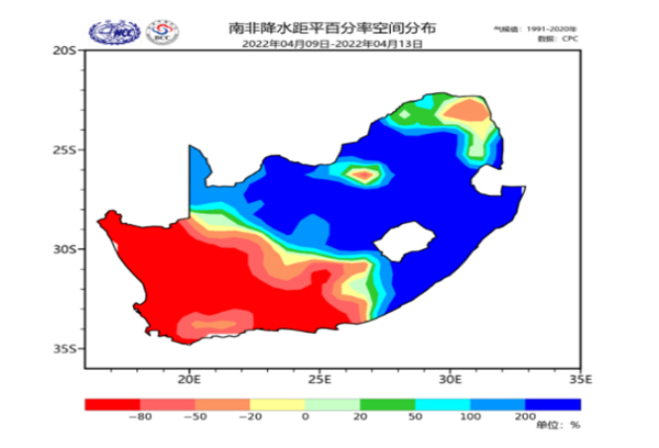
On October 30, 2022, a street in Cavite, the Philippines was inundated by flooding. 4. Eastern South Africa was subjected to the heaviest rainfall in about 6 decades and incurred heavy casualties. In the first half of April, 2022, KwaZulu-Natal province in eastern South Africa was in the grip of extremely heavy rainfall rarely seen in nearly 6 decades. The accumulative rainfall on its east coast exceeded 100 mm, and the local rainfall exceeded 300 mm, which was more than 2 times that of the same period of normal years. On April 11 and 12, 2022 alone, the local rainfall in KwaZulu-Natal exceeded 300 mm, shattering the historical maximum record in the past 6 decades. The city of Durban and surrounding areas experienced the rain of more than 450 mm in 48 hours, nearly half of the city's annual rainfall. Flooding caused by heavy rainfall has left more than 40,000 people homeless. Large swathes of land have been swamped, and many public and rail facilities and power systems have been damaged.
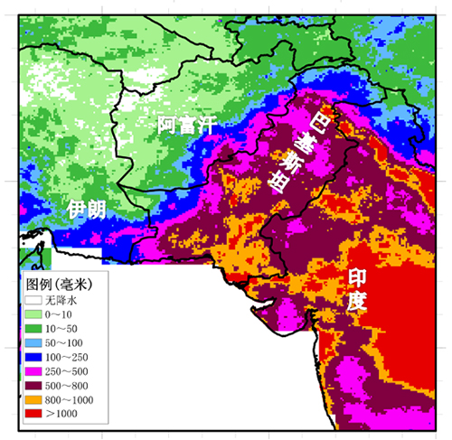
Percentage distribution map of precipitation anomaly over South Africa from 9 to 13 April, 2022 5. Record flooding has inundated one third of Pakistan. From June to August, 2022, Pakistan was frequently struck by heavy rainfall. The national average precipitation was 68% higher in June, 2022, 180% higher in July and 243% higher in August, 2022, among which the precipitation in July and August was the highest in the history of the same period since 1961. Sindh Province recorded precipitation of 1228.5 mm in August, 2022 and maximum daily precipitation of 355 mm, both setting monthly and daily records. Continuous heavy rains have inundated about a third of Pakistan, affecting more than 33 million people. 45% of the main crop, and cotton, have been destroyed by the floods. At the invitation of the Pakistani government, a Chinese government expert team composed of the Ministry of Emergency Management, the Ministry of Water Resources and CMA, paid a visit to Pakistan to exchange views on disaster assessment, disaster preparedness and shared China's experience in flood control and relief.
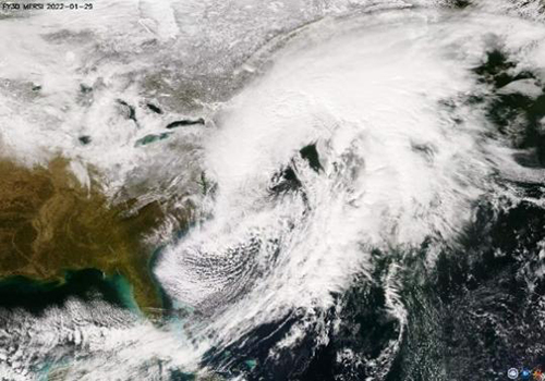
Summer precipitation real condition map of in Pakistan in 2022 6. Capital circle of Republic of Korea experienced the strongest rainstorm in nearly 10 decades, triggering serious waterlogging. From August 7 to 11, 2022, the capital area of Korea was hit by extreme rainstorm, which was characterized by long duration, short-term heavy rainfall and large accumulative rainfall. The maximum rainfall in one hour near the Korea Meteorological Administration (KMA) in Seoul recorded 141.5 mm, 259 mm in three hours, and 303.5 mm in six hours on August 8, 2022. The precipitation in Seoul registered 380 mm on that day, exceeding the usual rainfall in August and breaking the daily precipitation record, ranking the heaviest in nearly a century. Extreme rainstorm has caused severe waterlogging, inundation of many cities, submerge of subway and underground facilities, flooding of a large number of vehicles and landslides in some areas, forcing more than 7,000 people to evacuate their homes. 7. Extreme heat wave in summer sweltered in North Hemisphere, and severe drought occurred in a handful of countries. Northern Hemisphere was exceedingly sweltering in the summer of 2022. Sustained heat wave emerged in Europe, North Africa, the Middle East, Asia and North America, affecting the lives of nearly 5 billion people and causing wildfires in many countries. In mid-July, the temperature in Paris reached 40.5℃. The temperature in the UK hit 40℃ for the first time. The barometer registered 47℃ in Portugal. More than 60% of Europe was in drought due to high temperature and low rainfall.Wildfires were raging in many parts of the western United States. Extremely hot and dry conditions were making them difficult to contain. Central and eastern China has met with the strongest heat wave since 1961. The drought has affected sectors like food, shipping, and energy around the world, greatly affecting production and life. 8. Bomb cyclone and epic cold wave walloped the United States. In late January, 2022, a "bomb cyclone" hit northeastern United States, causing blizzard in several states. The winter storm blanketed 10 states in eastern US, including Massachusetts, New York and other states with strong winds and snow, with snow exceeding more than 30 cm. An "epic cold wave " swept across US from December 22 to 24, 2022. 240 million people across the US were warned of extreme cold. Two cold waves and snowstorms at the beginning and end of 2022 severely affected local transportation and power supplies. More than 10 thousand flights were canceled across US, and at least 1.6 million residential and commercial customers were cut off power.
Monitoring image of bomb cyclone captured by FY-3D 9. Volcano in Togo erupted, which might facilitated the occurrence of extreme weather and climate events. On January 14 and 15, 2022, local time, a series of underwater volcanoes in Hongahaapai, Tonga, the South Pacific, erupted. The main body of the ash cloud reached a height of about 18 km, which crossed the troposphere and reached the bottom of the lower stratosphere. The eruption was estimated to have produced about 3.6 million tons of volcanic mineral particles, making it the largest volcanic eruption in the world in nearly 3 decades.Tsunami warnings have been issued consecutively in Oceanian island nations, Japan, the United States, Canada, New Zealand, Australia and Chile. When volcanic ash entered the atmosphere, it could change atmospheric radiative forcing and produce the cooling effect, which has some influence on global climate. In addition, strong volcanic eruptions might increase the odds of local extreme weather and climate events.
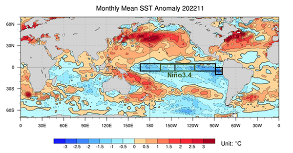
FY-4B monitored volcanic eruption in Tonga 10. Triple La Nina first emerged during the 21st century, affecting the climate condition in many regions of the world. According to the monitoring of the National Climate Centre, the current La Nina event in the equatorial Middle Eastern Pacific was continuing and was on track to peak in the winter of 2020/2023 and last until spring 2023. This would be the first "triple" La Nina event of the 21st century, namely, the formation of three consecutive winters. Globally, La Nina event can cause heavy rain and flooding in northern South America, an increased risk of flooding in northern Australia, Indonesia and Southeast Asia, and low rainfall in Argentina. When La Nina lasts for a long time, droughts will be common in central Africa and southeastern United States, and northeastern Brazil, India and southern Africa are susceptible to flooding. From late May to early June 2022, persistent heavy rainfall pelted northeastern Brazil. In the past two years, continuous drought in Ethiopia, Kenya, Somalia, Uganda, Sudan and other countries in central and eastern Africa had caused food shortages and worsening ecological conditions, all of which were related to La Nina event to some degree.
Global sea surface temperature anomaly distribution in November 2022 (unit: ℃) and Nino3.4 region (170°W-120°W; 5°S-5°N) position diagram Editor: Liu Shuqiao Previous issues
|

