


Updated: 13-11-2013
Source:

FY-3C has been launched successfully at 11:07 a.m. of September 23, 2013.
At 11:07 a.m. (BJT) from Taiyuan Satellite Launch Center, September 23, 2013, the carrier rocket Chinese Long March 4C lifted off to send Fengyun (FY)-III 03 satellite of CMA into predetermined orbit. The launching process is completely successful. The orbital satellite is referred to as FY-3C after launched and has higher capabilities of integrated earth observations. On October 21, 2013 to January 20, 2014, CMA officially carried out in-orbit testing of FY-3C meteorological satellite. The testing will be finished on January 1, 2014.
FY-3 series are the Chinese second-generation polar-orbiting meteorological satellites, which aim to realize all-weather, multispectral and 3D observation for global atmosphere and Geophysical factors. This FY-3C is launched into a morning orbit, and its missions are mainly earth surface imaging and atmospheric sounding, and its observational data are to be used in weather forecasting, as well as natural-disasters, ecological, and environmental monitoring.

Global image of FY-3C VIRR orbit in daytime.
On May 27, 2008 and November 5, 2010, CMA launched meteorological satellites of FY-3A and FY-3B. They have been widely applied into Chinese and global weather forecast, climate prediction, ecological environment and monitoring disasters.
In comparison with FY-3A and FY-3B, the payload on board FY-3C has been improved, which has 12 sensing instruments, including Visible Infrared Radiometer, Microwave Scanning Radiometer, Microwave Temperature Sounder (MWTS), Microwave Humidity Sounder (MWHS), Microwave Imager, a Medium Resolution Imaging Spectrometer, UV-ozone sounder, Total Ozone UV Detector, Solar Radiation and the Earth Radiation Detector, Space Environmental Monitoring Suits, and GNSS Occultation Detectors. Among them, the MWTS and MWHS have been upgraded to the version of Ⅱ which could enhance the precision of atmospheric sounding. Meanwhile, the new added payload GNSS Occultation Detectors could improve the capabilities of 3D and vertical sounding for global atmosphere.
The FY-3C will replace FY-3A to operate after test in a morning orbit with FY-2B which is in an afternoon orbit. Then the temporal resolution of global observation data will be up to 6 hours.

VIRR image for typhoon Fitow (9:45 a.m. BJT of Oct.2, 2013)
VIRR
Visible and InfraRed Radiometer (VIRR) of FY-3C possesses ten remote sensing spectral bands, which cover visible and infrared every wavebands. FY-3C improves the sensitivity of VIRR, promotes the inversion accuracy of quantitative products involving in atmosphere, lands and sea surface and provides the protection for climate database establishing of sequence satellites.


Global image of IRAS visible near-infrared channel
IRAS
Infrared Atmospheric Sounder (IRAS) of FY-3C is an infrared sounder for vertical atmosphere profile with a total of 26 channels. The first 20 channels are almost the same as the High-Resolution Infrared Radiation Sounder (HIRS)/3, while the other six enable the IRAS to measure aerosols, carbon dioxide content, and cirrus. The IRAS instantaneous field of view (IFOV) is 17 km at nadir. Its products include atmospheric temperature profiles, atmospheric humidity profiles, and outgoing long-wave radiation.


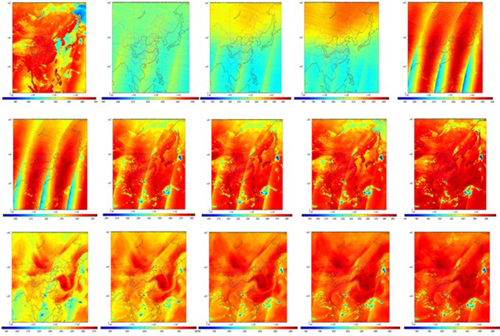
Global brightness temperature image of MWTS-II Channel 1 &2.
MWTS-II
Microwave Temperature Sounder -Ⅱ(MWTS-Ⅱ) of FY-3C is a passive scanning microwave sounder capable of temperature sounding in cloudy sky. It increases its channels from four to thirteen to improve the vertical resolution and comprehensive capability of detecting. Its products are atmospheric temperature profiles and surface emissivity. MWTS-Ⅱ could provide powerful support for warning and monitoring of typhoon, rainstorm and severe convective weather.

Global image of MWHTS Channel 1 (89 GHz).
Projected image of 15 channels of MWHTS.
MWHTS (MWHS-II)
The Microwave Humidity and Temperature Sounder (MWHTS) added channels into fifteen from five. It has added a sounding channel of temperature profile in oxygen absorption line (118GHz), extended the sounding channel of moisture profile (183.31GHz) and added the channel of atmospheric window region (89GHz). MWHTS could provide initial field information for numerical weather prediction, and then improve the monitoring and warning capabilities for severe convective weather.

MERSI global image of Oct.2, 2013 (R:B3, G:B2, B:B1).

MERSI image for Arabian Peninsula and Middle East (07:05 BJT of Oct.1, 2013)
MERSI
The Medium-Resolution Spectral Imager (MERSI) has the characteristics of multispectral, high sensitivity and high spatial resolution. The five special channels with the spatial resolution is in 250 m, not only can be used to create the high-resolution imagery of the earth in natural color ,but also can be used to get the high resolution thermal infrared radiation image in the global scale. The MERSI products record the land surface reflectivity, high-resolution vegetation index, land-cover types, ocean color, aerosols, and atmospheric precipitable water.

MWRI ten channels global image (Oct.2, 2013).
MWRI
The Microwave Radiation Imager (MWRI) can monitor the severe weather, such as typhoon, convective clouds both in clear sky and cloud sky. The microwave imager with wavelengths longer than 1 mm in some channels can penetrate clouds and provides forecasters with all-weather measurements. At higher frequency channels, such as 89 GHz, the scattering signatures from clouds and precipitation are also good indicators for detecting rainfall over both land and ocean. The typical products of the MWRI are precipitation and cloud water, atmospheric precipitable water, sea surface temperature, soil moisture and temperature, and snow cover.

ERM observation global image (Oct.2, 2013)
ERM
Earth Radiation Measurement (ERM) is the instrument similar to the Earth Radiation Budget Experiment instrument on board the National Oceanic and Atmospheric Administration satellites. It separates wide-FOV and narrow-FOV observation units, each with two channels. The broadband channel covers the spectrum ranging from 0.2 to 50 μm, while the narrowband channel covers 0.2–4.3 μm. The ERM products are solar radiation flux and outgoing long-wave radiation flux.
SIM-II
Solar Irradiation Monitor-II added the active trace facility of the solar to ensure the stability of incident light. Meanwhile, the instrument also added the function of precise temperature control to improve the quantitative observation accuracy.
SEM
Space Environment Monitor (SEM) can effectively monitor the space environment and the charged particle flux, record impacts of space weather events on the satellite, and provide important data for space weather monitoring and warning. It maps the occurrence and location of high energy particles.

Ozone hole of the South Pole distribution image by TOU inversion
SBUS and TOU
The Solar Backscatter Ultraviolet Sounder (SBUS) and the Total Ozone Unit (TOU), are sensors for measuring atmospheric ozone distribution. The TOU is a six channel spectrometer with wavelengths from 308 to 360 nm and a resolution of 50 km at nadir. The SBUS is a 12-channel spectrometer with wavelengths ranging from 252 to 380 nm. The spatial resolution of the ozone profile is around 200 km at nadir. The typical products of the SBUS and TOU are global vertical ozone profiles and total column ozone. They provide important data and parameter for ozone monitoring.

Occultation points distribution image of GNOS.
GNOS
GNOS is the new instrument to receive shadowed GNSS signal of the earth atmosphere and ionosphere by GNSS receiver of FY-3C, and then get temperature, humidity, atmospheric refractive index and other parameters. GNOS receives the Occultation signal not only from GPS, but also from Chinese Beidou navigation system, which is the first time in the world. It has the characteristics of high precision, high stability, high vertical resolution, all-weather to improve the capabilities of 3D and vertical sounding for global atmosphere.
Editor: Hao Jing


